AI TRAFFIC
A multipurpose AI focused on Smart Cities and Traffic, with Pedestrians, Cyclists and Vehicle management. Ful UTC and UTMC support.
Now Wireless AI/Bluetooth Full Integration with Senseview
AI Traffic
Count and Classify: Pedestrians, Cyclists, Vehicles
Track: Pedestrians, Cycle, Vehicles
Overhead Detectors: Stop Line Detection, Road Loops, Remote Loops. A Virtual Loop requires no road works.
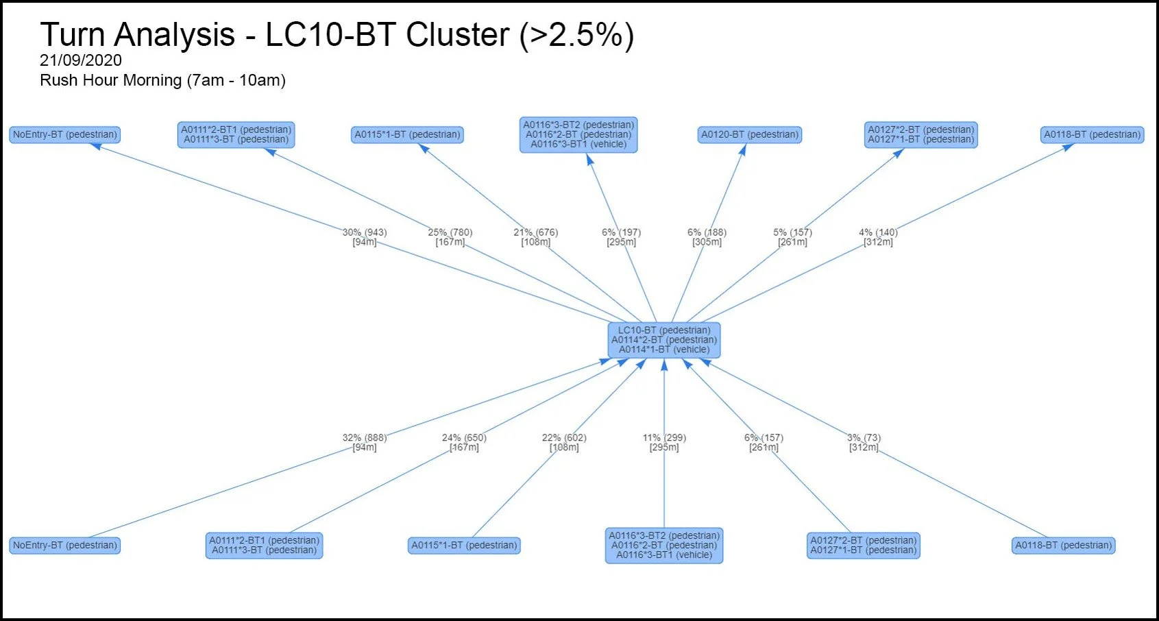
Turn Analysis: Monitor where Peds, Cyclists and Vehicles travel
Start End Journey: Where do Pedestrians, Cyclists and Vehicles start their Journey
Parking: Car Parks, On Street Count and record for billing and management
ANPR: Provide Journey Time, Turn Analysis
Queue Detection: Provide Q management
Low Emission Zones: Integrate into DVLC systems to check vehicles for Pollution and interface to billing
Road User charging: Provide Information for billing
Air Quality: to actual and predicted pollution types and adjust traffic based on this.
Gather and present. detailed Information for insightful policy decisions and road design
AI Hardware
Artificial Intelligence
AI Edge - up to 16 cameras per processor, depending on the Model
AI-Control Room - designed for control rooms, handles up to several hundred cameras, depending on the model.
Loop Interface modules - Provide signal input to the Controller as if it were a loop in the road
Virtual Loops
Data-driven traffic light management
Traditional loops requiring road works are replaced by AI, sensors and a camera
Resulting video analytics allows vehicles to be counted and classified
Identifies traffic hotspots and automatically triggers mitigation measures
The AI is flexible and can be trained to identify pedestrians and 17 vehicle types

Virtual Cycle Lanes
Giving the proper priority at the right time
Cycle lanes are most difficult in side streets
Existing technology doesn’t help - it either closes the street or risks cyclists’ safety.
Our video analytics allow cycles to be detected and given a green wave across junctions.
Prevents accidents to improve city safety records
Allows roads to remain open

Automatic Pedestrian AI Technology
Creates a Pedestrian first Environment
First pedestrian crossing lights that change without being touched
It uses AI and machine learning to predict behaviour by identifying travel patterns of road crossers and working out their intentions.
Keeps traffic flows moving rather than stop/starting vehicles unnecessarily
Helps tackle climate change, meet air quality targets and keeps pedestrians safe
Highly cost-effective as no expensive road works are required for installation

Pedestrians
Functions Available for Pedestrians
Counting Pedestrians
Tracking Pedestrians Using Digital Signature
Contactless Crossings using Video Analytics
Management of Central Islands on Pedestrian Crossings

Cycles
AI Functions for Cyclists
Counting Cyclists
Tracking Cyclists using Digital Signature
Virtual Loop for Cyclists – Seamless traffic management integration
Virtual Cycle Lanes – Cycling green waves for safe routing

Vehicles
AI Functions for Vehicles
Count Vehicles
Classify Vehicles
Virtual loop - Seamless Traffic Light System Integration
Speed Detection
Bus Priority - Detect Local buses and give them priority
Manage Air Quality

Parking
Parking
Counting free spaces in a row of car parking
Alerts on Car Entering Space
Alert on Car leaving space
Off-Street Parking and Car Parks
Car Staying past limit alert
Photograph and ANPR options
API for Billing Engine

Tracking
AI based Tracking
Tracking across multiple cameras - ribbons
Turn analysis on junctions
Pedestrian, Cycling and vehicle tracking with a Digital signature
Rat Run detection

Road User Charging
Low Emission Zones Management
Digital Signature monitoring
Beacon Monitoring
ANPR capture
Interface to Billing Engine
ANPR Pre and Post-processing

Traffic Monitoring
Intelligent information for traffic managers
Slow Traffic Alert
Stopped Traffic Alert
CAV Interfacing
Incident Detection
Dynamic Area of Interest alerting

Enforcement
AI-DRIVEN ENFORCEMENT
Yellow Box
Illegal Turn
Bus Lane
Parking
One Way Street
Road User Charging
Pollution Detection
API for Billing Engine
ANPR option

Weather and Pollution
Environmental Analysis
Pollution Tracking and Prediction
Rain Measurement with a Low-Cost Sensor
Local Weather Station alerts
Mist Detections
Standing Water Detection
Flood Warnings

Start and End Journey
Where do vehicles go?
Video analytics gives detailed turn analysis.
Digital signatures tell us where they are going and where they come from
AI analysis of collected data provides detailed insights to road user usage
Capable of showing devices’ journeys throughout the whole day
Can identify non-stand vehicle routing
Virtual Loops and Stop Line Detection
Remove Physical Loops with AI
An option to introduce AI is to replace something that is required often: Loops
The new ARTMS standard will need AI to input to UTC to give more information to OTU
Traditional loops requiring road works are replaced by AI, sensors and a camera
Resulting video analytics allows vehicles to be counted and classified
The AI is flexible and can be trained to identify pedestrians and vehicle types
Can you provide all the features of the following slides

Queue Detection
Any Camera can be used to have a selected area used to detect if a Q has been formed
Detects Q’s
There is no Movement of a group of cars in the box
Slow Movement cars in the box
Triggers Alert Email or Loop Pulse/State

Turn Analysis
Cars at Junctions can be Counted by which direction they left the junction
Detects objects in one box moving to another Box.
Count of each box plus pairs of boxes
So we will get count 2 and 3 as well as 2/3 count

ANPR
AI now can provide ANPR information as well as classification
Provides Journey Time as another option added to Bluetooth
Provides all functions now associated with Bluetooth
Number Plates can be forwarded to DVLA to extract vehicle Classification and Pollution Rating
ANPR allows Classification Extensions
Turn Analysis and Journey Time

Bus and Taxi
AI can detect a bus and give a green wave whilst logging cars in bus lanes and bus stops.
Provides Journey Time using ANPR or Bluetooth
Special Bluetooth Buttons recognise temporary buses, such as football coaches.
UTC and UTMC interface
Bus and Bust Stop detection to delay traffic light change

Virtual Loops
Removes Physical Wire Loops in the road, saving road works, Traffic Management and Environmental Concerns
A Camera is pointed at a section of the road
An AI maps a series of boxes in which it detects the presence of vehicles
The IA triggers an I/O device to signal that the vehicle is in the box identically to the physical loop
A single camera can trigger multiple loops, and 8 to 16 cameras can be driven by one AI
Pollution Prediction
AI-powered pollution analysis and monitoring
We can monitor and anticipate pollution build-up with 99% accuracy to trigger real-time remediation
AI calibration is also used to ensure long-life pollution sensors stay accurate.
Used by local authorities to make their cities cleaner and smarter

Air Quality

Car Vehicle Motion Tracking
Graphical Display of Vehicles through a Junction
Cars’ movement through frame tracked and vectors showing
It can be displayed as a trace on the camera image
Demand Lines

DVLA
Requires Free Key from DVLA
Sends ANPR to DVLA
Gets the Classification of the vehicle
Gets Pollution Value
Train AI on Classification
The DVLA interface is accessible, requires Wolverhampton to request a key from DVLA, allows 10 vehicles per second and is queued.
Once a reply is received from DVLA, the number plate can be deleted or stored for 30 days. All Number pLates are hashed the same as Bluetooth. A number plate tagged can be hashed.
Car Park Camera
AI v2.6 Can count the number of Vehicles/ People in an area
Define the number of boxes; each box has many cars
AI counts the Vehicles and alerts when a new Vehicle enters or leaves the box
Multiple Boxes on different cameras are added to create a CAR PARK and total aggregated
ANPR Supported

On Street Parking
Ilegal parking, Parking off street
Check when the vehicle parks with ANPR and the time
Notes when leaves with time
Sends alert if overstays the time
Photo Taken

AI Categories - Multi-Layer
All in one AI using ANPR, the Vehicle Classifications can be extended by having more images to train.
Vehicles - ANPR allows self Classification and training; previously challenging to get several images to train the AI
Bikes - Now integrates with the Vehicles
People - Works on different models, but using Multi-Layer will be on the same AI.
Multi-layer AI allows multiple models on the same AI, will allow custom local AI variations as well as integration of people into the same AI
Lo.cal Bus training and other types can be added using Multi-Layer
Multi-Stacked Models
Allows Several Models to be run on same AI
Allows multiple AI models on the same AI
Each AI Pulls a Video Stream
Models are independent and allow for unique models to be developed for Emergency Vehicles/Taxis.
It can be used for Bus Lane enforcement with the simple model, while complex model is ANPR and Classifications.

Traffic and pedestrian Journey analysis
AI analysis of Digital Signatures and Video Analytics
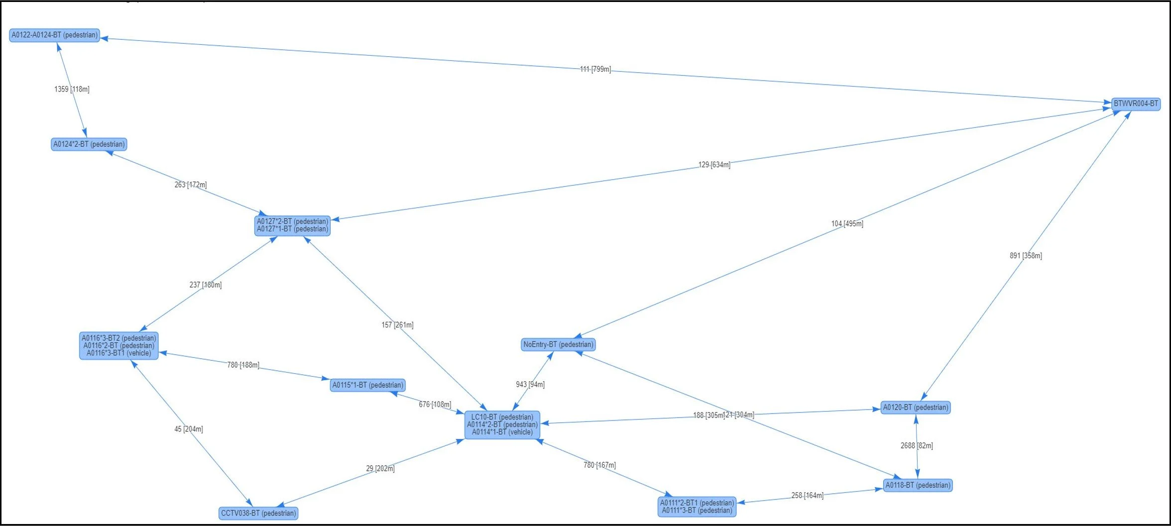
Route and Turn Analysis
Where do vehicles go
Video Analytics gives detailed turn analysis.
Digital Signatures tell us where they came from and where they are going
AI analysis of collected data to provide in-detail insights into road user usage
Capable of showing device journeys throughout the whole day.
Can quickly identify non-standard vehicle routing
Easy data export

Virtual Cycle Lanes
Giving the right priority at the right time
Cycle lanes are most difficult in side streets
Existing technology doesn’t help - it either closes the street or risks cyclists’ safety.
Our video analytics allow cycles to be detected and given a green wave across junctions.
Prevents accidents to improve city safety records
Allows roads to remain open

Automatic Pedestrian AI Technology
Can count the number of pedestrians, can track movement and trigger lights
First pedestrian crossing lights that change without being touched
It uses AI and machine learning to predict behaviour by identifying travel patterns of road crossers and working out their intentions.
Keeps traffic flows moving rather than stop starting vehicles unnecessarily
Helps tackle climate change, meet air quality targets and keeps pedestrians safe
Highly cost-effective as no expensive road works are required for installation
Where there is an island in the middle Camera can count the number of people on the Island
